
In an IELTS task 1 map you often have to
compare a map from the past with one from the present.
Different
Kinds of Map Question
There
are three main types of map question:
- Describe
one map in the present day.
- Describe
two maps- one in the present and one in the future.
- Describe
two maps- one in the past and one in the present.
The
first kind is very rare, as it only requires you to use the present simple and
it is impossible for any comparisons to be made.
The
second kind does come up occasionally and would require you to use present and
future tenses. This kind of question is normally about the future development
of a town or city. It requires the same vocabulary as the other two.
The
third is the most common and will be the main focus of this post.
You will normally be shown two maps, as above and asked to select
and report the main features, and make comparisons` where relevant. You will
obviously be using both present and past tenses to describe the maps and how
the town has developed.
How to Tackle Maps in IELTS Writing Task 1
Questions
1.
Introduction:
Paraphrase the question.
2.
Overview: Describe
what you consider to be the major changes over time.
3.
Body paragraph 1:
Describe the first map in detail.
4.
Body paragraph 2: Describe
the second map in detail.
You should spend about 20 minutes on this task.
The
maps below show the village of Stokeford in 1930 and 2010.
Summarise the information by
selecting and reporting the main features, and make comparisons where relevant.
Write at least 150 words.
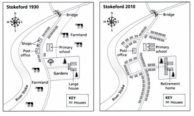
The maps compare the structural developments and the transformation of a village called Stockford between 1930 and 2010.
A glance at
the maps reveals that the Stockford village in 1930 had fewer houses and
extended farmland but witnessed rapid housing development afterwards.
As is
observed, Stockford village is located at the east of the River Stoke. Parallel
to this river, the main road has connected a bridge in the farthest north-east
side of the village in both maps. A few houses on both sides of the road, two
shops and a post office on the west side of the road were present in this
village in 1930. Besides, an elementary school, a large garden and a connecting
road to the bridge were on the east of this village. Two large farmlands were
quite visible in the early map which disappeared in the latter one.
The 2010's
map reveals that the post office, the bridge and the primary school remained
unaltered, though, the school building was enlarged. The shops disappeared and
the garden with many of its trees was compromised to build more accommodation
facilities. The large house was converted to a retirement home with some extension
to its structure. On top of that, the number of houses increased remarkably and
these houses were built on the previously existing farmlands and garden.
(221
words)
Sample 2
You
should spend about 20 minutes on this task.
The two maps below show an island, before and after the
construction of some tourist facilities.
Summarise
the information by selecting and reporting the main features, and make
comparisons where relevant.
Write at least 150 words.
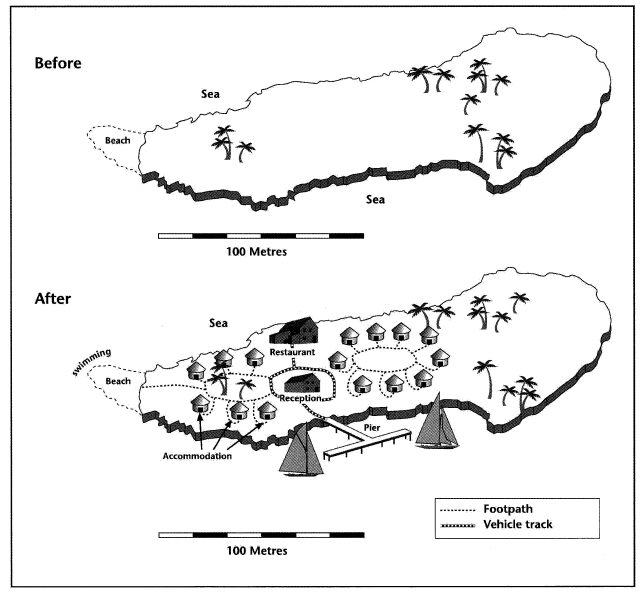
The map illustrates the changes on an island after the construction of some tourist facilities.
Generally speaking, the island was deserted as no tourists facility was there, but after the renovation, tourist amenities like the pier, restaurant, several accommodations, reception on the island, roads etc. made it tourists friendly.
The first map shows nothing
on the island except some trees but the second map illustrates the changes
after the construction of facilities. A pier for the boats to land could be
seen and from there, a vehicle track leads to the reception area and then the
restaurant. Vehicle track ends near the restaurant and the footpath leads
tourists to the accommodation areas and to the beach. Residential areas are
located on both sides of the reception with footpath connecting them.
It is worth noticing that no
woodcutting took place as trees are present in both maps. On the left side of
the reception, the residential area is connected to the beach via the footpath.
Swimming facility is available there as well.
(171 words)
You
should spend about 20 minutes on this task.
Sample 3
The map below shows the
development of the village of Ryemouth between 1995 and present.
Summarise the information by selecting and reporting the main features and make comparisons where relevant.
Write at least 150 words.
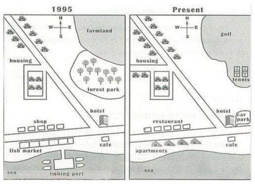
The
maps provide an extensive illustration of the village's remarkable
modifications between 1995 and the present day.
In general, the village map has undergone substantial changes with the significant increase in the number of houses and shops, and the conversion of farmland and woodlands into sports facilities. These new sporting facilities and the overall expansion of the village have brought about a significant transformation to the area's economic, social and physical landscape.
In the northeast of the village, a forest park now stands where there was once farmland. There are still several roads that run from north to south and east to west, with homes on both sides of the north-eastern road concentrated in the northwest corner of the village. On the east-west road, the same hotel and café established in 1995 continue to thrive. However, the southern side of the hamlet shows the most striking alterations.
In the present-day map, the fishing port has disappeared into the water, and a range of apartments and restaurants have taken the place of the former fish market and row of small shops. On the village's north-western side, four more houses have been built beside the roads. Moreover, a parking lot has been established by the hotel, and the former farmland and forest park have been transformed into a golf course and two tennis courts, offering residents new recreational opportunities.
Sample
4
You should spend about 20
minutes on this task.
The map below is of the town of
Canterbury. A new school (S) is planned for the area. The map shows two
possible sites for the school.
Summarise the information by
selecting and reporting the main features, and make comparisons where relevant.
Write at least 150 words.
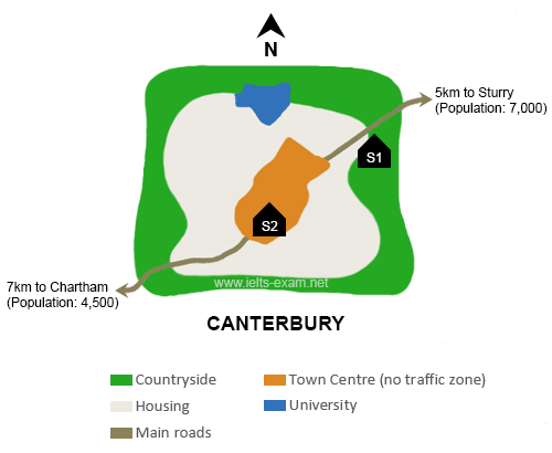
The map given below shows two proposed
locations for a new school in the town of Canterbury.
Overall, while S1 is located in the country side where there is more population, S2 is easily accessible by everyone as it is located in the Town Centre.
The first preferred location S1, would be located in the countryside towards the south east of the university and on the outskirts of housing. This site is situated very close to the main road connecting Sturry which is distant from the Town Centre by 5kms. If the school is set up in this location, it would easily be accessible only to the residents of Sturry and population of Chartham would have to travel a longer distance to reach the school.
The next preferred site is S2 in the Town Centre. As per this proposal, the upcoming school would be built towards the south of the university in the no traffic zone having an almost equal access to both Chartham and Sturry via main roads. Surrounded by housing on all sides, it would be reachable for everyone and can cater to the needs of a larger popular.
Sample 5
You should spend about 20 minutes on this task.
The map below shows the changes in an American
town between 1948 and 2010.
Summarise
the information by selecting and reporting the main features and making
comparisons where relevant.
You should write at least 150 words.
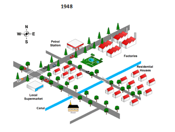
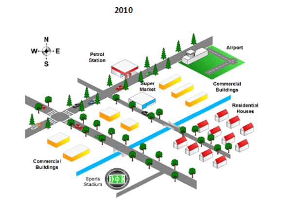
The maps portray the modifications which took place in an American town between 1948 and 2010.
Overall, in spite of some significant changes, the dimension of town did not alter. However, these variations manifest that the town developed gradually in terms of everything during this interval.
Looking at the details, there was some significant variability. From the middle of town up to north-east, the surrounding lake with trees and the factories were situated in 1948. In 2010, these places were modified to a supermarket, commercial buildings and the airport. At the same time in the bottom right-hand corner of the town, the sports stadium replaced the church during this time. Residential houses and local supermarket were substituted with commercial buildings.
By
contrast, the residential houses which were located on the right side of the
canal and the petrol station situated in the north of the town did not change
their positions all through a period of time.

No comments:
Post a Comment